ATV Adventures: More fun at the National ATV Jamboree in Fillmore


-

- Riding the beautiful Fillmore trails in the tops of the mountains.
-

- Negotiating a 50-inch gate at the top of the Paradise Canyon Trail.
-

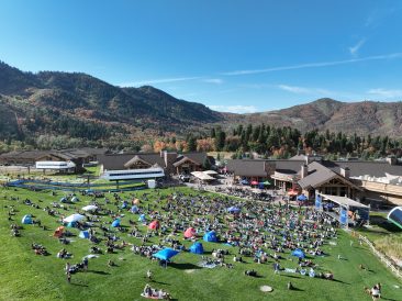
- Machines lined up for fun at jamboree headquarters in Fillmore.
-

- Lynn Blamires
I have written about the fun we had spending time with friends at the National ATV Jamboree and a new trail I was introduced to on that first day. The next two days were also filled with fun. Burnt Fork was the first of two trails we took.
One thing I have learned about names given to ATV trails is that they are often specific to the groups who ride them. I was on a ride on the Lower Kimberly’s in this same trail system when we stopped at an old collapsed mine shack. Another group of riders stopped at the same place. In our conversation, we learned that they called it “The Tuna Place.” To my inquisitive look, they said, “When we reach this point, we always stop and open a can of tuna fish.”
As we started out on the Burnt Fork ride, I hoped to learn how it got that name. On this ride, we went west of Fillmore by the mushroom plant and onto the frontage road toward Meadow and then onto Kanosh.
We climbed up Kanosh Canyon where we stopped for a break at the Adelaide Campground. We then crossed Corn Creek and went by Middle Mountain. With all the mountains we have in Utah, how you determine which one is the middle one is beyond me.
We turned left at Cottonwood Creek and the climb got steeper. We came onto the main Paiute Trail No. 01 at Indian Flat and turned right, passing through Chokecherry Hollow.
Continuing to climb, we stopped for a break at a junction where the main trail went south to the Fremont Indian Museum. We were in a huge stand of aspen and it was a good place to stop.
Moving on, we passed side trails that went down to Joseph and Elsinore and then we came to a junction that dropped down into Richfield. The map here is marked Burnt Hollow. Could that be the same as Burnt Fork? The guide said it was close enough.
We continued on the No. 01 where we stopped for a break below White Pine Peak. This was one of the prettiest parts of our ride. We were riding the ridge high on the mountain and the scenery was beautiful. We then made our way down Sand Rock Ridge into town finishing a ride of about 69 miles.
Our third ride was the Fillmore Loop. I was familiar with this one. The ride began on a trail up Sand Rock Ridge, the trail we had come down on the day before. We took a break at the top where there is a restroom. Where there is a restroom there is a line of people — there just is.
The second leg of the loop goes across the top of the ridge to meet up with the trail down Chalk Creek Canyon. This is the prettiest part of the loop.
I like to stop at the first junction on this leg. At this point, I can look up high where an arrow is embedded in a tree. I figure the snow was 50 feet deep or a hunter got excited and aimed high. It has been there for years.
We stopped at the top of Chalk Creek Canyon where it started to rain. We knew the way back to town and signed out of the ride. As it turned out, we were parked under a rain cloud. It was dry the rest of the 51 miles back to town.
Four campgrounds grace the lower part of this canyon and their names piqued my historical interest. Sherry Shepard who writes a column called “The Face of Fillmore” filled me in.
Sherry said, “Early residents used the canyons and their natural resources almost immediately after settling Fillmore. Roads were promptly built into the canyon to harvest lumber for use in building the fort and their homes inside it. In later years, the canyon was also used for recreation — a retreat from the summer heat of the valley.”
Copely’s Cove Campground was named for a cove there, but no one knows who Copely was. Shingle Mill was named for a creek and the site of a lumber mill. Pistol Rock was named after a rock that no one can find that looks like a pistol and the Buckskin Charlie Campground was named after a Ute Indian Chief.
And now you know. When you go, take plenty of water, keep the rubber side down and enjoy the Fillmore trails.
Contact Lynn R. Blamires at quadmanone@gmail.com.