ATV Adventures: Paiute ATV Adventure Part 3 – Finding our way back to Fillmore


-

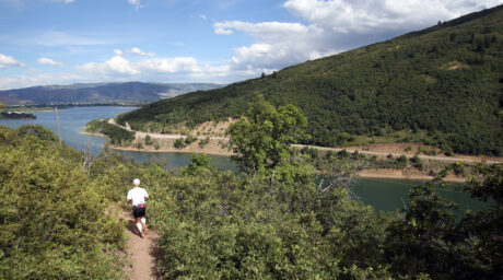
- Riding through a hint of fall colors on the last leg of our Paiute ATV Trail adventure.
-

- Lynn Blamires
It was the morning of the third day of our Paiute ATV Trail adventure. Reading part two last week, you will know that some of us slept better than others.
We gathered at Tugs, the only filling station in town, for a council and to give time to those who had not topped off their tanks the night before. Since there was no place for breakfast in Marysvale, we decided to ride to the Big Rock Candy Mountain restaurant.
That was the best decision we had made all day. Of course, it was early in the day, but we were optimistic.
The next decision we made was a disaster. As we left the restaurant, our system for staying together fell apart and everyone got lost.
Thanks to cellphone service, we found everyone and brought our two groups together on the north side of Hoover Peak. We regained our composure and headed for Monroe.
We crossed Sage Flat on trail No. 22 and then took a trail over to No. 24 in Long Valley. This took us to the south side of Monroe where we started our climb to the top of Monroe Peak on No. 78.
A side trail took us to a radio tower at the very peak of the mountain. The elevation put us about 175 feet lower than where we were the day before on top of the Tushar Mountains. We could see them in the distance across the valley. Being above the tree line, their bald peaks stood out clearly.
One of the things I enjoy about the Paiute Trail System is the diversity found in the ecosystems. The high desert conditions in Marysvale Valley contrast with the forested mountain settings separated by the valley.
An interesting section of the trail system is found on either side of Interstate 70. The south side has more of a lush forested setting with tall pines and aspen. In contrast, the north side is dry and rocky with little ground foliage among the junipers.
One feature that accompanies the remarkable views from high peaks is strong winds. Monroe Peak was no exception. We endured the winds to enjoy the views and then rejoined the main trail.
We began our descent on the east side, crossing Sawmill Flat by Monkey Flat Ridge and then taking No. 44 through Monroe Meadows to a restroom near Indian Peak. It is one thing to take a ride in the mountains and another thing to know the names of the places you are visiting.
Each name has a story if you are willing to do the research. Learning about the history of those names makes the ride more fun for me.
From the bathroom break, we took No. 4 by Monument Peak around the southeast side of Big Lake. After crossing Hunter Flat and Bell Rock Ridge, we dropped down into the tiny town of Annabella. It was a straight shot from there into Richfield.
I was looking forward to our accommodations. That meant a hot shower that didn’t require coins, a comfortable bed and a hot breakfast in the morning.
With the extra miles I rode to gather our group of 12 machines that morning, I added another 93 miles to our adventure. We enjoyed talking about the ride we had that day over dinner at the Black Bear Diner.
We met the next morning where 300 North in Richfield goes west under I-70. This is the same No. 4 that brought us into town. It climbs around a big, pink water tank that has become a landmark on that trail.
We climbed the trail by Little Valley and over a ridge into Burnt Hollow. Instead of taking the main trail back to Fillmore, there is an enjoyable side trail marked No. 508 on the map.
It takes off of the No. 1 near a little cattle pond. Climbing over some ridges, it winds through the woods and rejoins the main trail. Some in the group remarked that it was a highlight of the ride.
We rode in the tops of the mountains until we came to a junction that took us down into Chalk Creek Canyon. It was on the north leg of the Fillmore Loop, the one we took two days ago.
Riding into Fillmore, we added another 52 miles to an amazing adventure that totaled about 310 miles. What a ride! When you go, take plenty of water, keep the rubber side down and plan your ride on this wonderful trail system.
Contact Lynn R. Blamires at quadmanone@gmail.com.