Logandale Trails
We are in the sixth month of 2010 and the mountain riding season in Northern Utah still isn’t open. As cold and wet as this spring has been, I became desperate to find a trail to ride and write about. I can’t just make these things up, you know. It was March and I was ready to ride.?
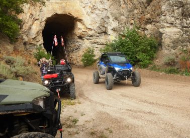
I was sure that I would find the sun in Southern Utah in March. I convinced some of my friends to come frolic in the southern sunshine with me. “Trust me,” I said. We loaded up full of optimism and headed south.?That optimism waned as we approached Cedar City to find that I-15 was closed due to a multi-car pileup caused by icy conditions. We were diverted through Enterprise and arrived in Hurricane at our motel not at all surprised that no one was in the swimming pool.?Morning dawned with news that trails we had planned to ride were buried under two feet of snow. I suddenly found six pair of eyes staring at me with a look that meant I had better come up with a warm trail to ride. “No problem,” I said, “we just need to go further south.”?We traveled through the Virgin River Gorge past Mesquite, Nevada and took exit 93 onto Highway 169. We soon found ourselves in the sleepy desert town of Logandale: population 2,263.?We turned west at the sign marking the Logandale Trails and followed a dirt road over the railroad tracks a short distance to a large staging area. We unloaded our machines in warm weather with smiles on our faces.?The Logandale Trail system is laid out on the border of the Valley of Fire State Park. From the very beginning of this trail, we knew we had ridden into an entirely different world. Burning red rock ridges jutted out of the sand in ragged points, each formation unique in its folds and creases.?Our track took us across a section of the northernmost part of the state park and through Logan Wash. We traveled south down a canyon on rose-colored sand bordered by cathedrals of red sandstone. I like to call it burning red rock; it just made me feel warmer saying that. The temperature was in the high 60s and the sky was an azure blue. It was the perfect day for a ride.?We came to a spot where a sandy trail broke off the main track and climbed into a pocket surrounded by a pinnacle of stone. I took the steep ascent to the turn-around and looked down on the other riders. They looked like big beetles crawling around.?We took a lunch break at a sandy spot near the red-rock cliffs. Then we had a treat that was better than dessert. We hiked west to the cliff face and viewed panel after panel of pictographs chiseled into the rock by Indians long ago. The depictions were so varied; I wondered what messages they may contain.?We took another side track that took us up on a high knoll to get a panoramic view of the area we were riding. We were at only about 2,200 feet, but the view was nice. It was a clear day and we could see for miles in all directions.?We came back to the main trail and headed south for a while and then the trail turned east. We took one more side trail that took us out of the sand and over a slick-rock trail into an out-of-this world moonscape.?We made one more stop to climb onto a rock ledge big enough to allow us all to line up side-by-side and then we headed back for the trucks. ?This is a one-of-a-kind place to ride. It is best ridden October through April; the summer would be too hot for those of us acclimated to Northern Utah. Should you decide to go, take a camera, plenty of water, and keep the rubber side down.?
You may contact Lynn Blamires at quadmanone@gmail.com.