Layton’s Eastridge development in full swing; some still fear landslides
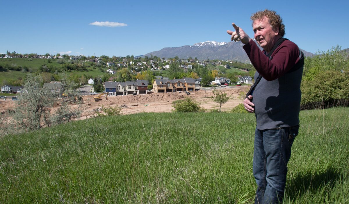
Don Berube points out where new homes are going in at the Eastridge Park development along East Antelope Dr. on Wednesday, May 11, 2016. Berube, who lives next door, is worried about how the development will impact the surrounding homes. "Anyone can do what they want with their property," said Berube, "but their rights have to stop when they start infringing on mine."
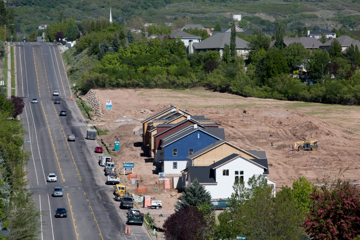
The first townhomes in the Eastridge Park development along East Antelope Dr. are constructed on Wednesday, May 11, 2016. Some neighbors are worried about the traffic and potential for landslides as the hilly land in Layton is developed.
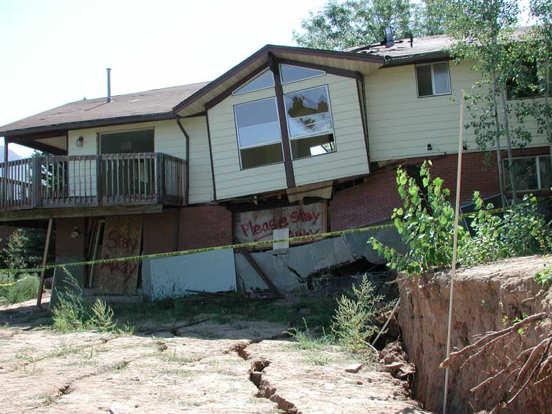
Three homes were demolished and three others had to be moved after a landslide struck Heather Drive in Layton in August 2001.
LAYTON — If you live in east Layton, you probably know about landslides. That’s why some residents are having a hard time shaking feelings of foreboding as a 70-acre residential housing development hits high gear on Antelope Drive at 1450 East.
Despite assurances by developers, city officials and geologists that sweeping precautions have been taken and risks of sliding are minimal, nearby residents say they’re being watchful.
“We don’t like it,” Shirley Berube, who lives at the west end of 1480 East, which sits above the growing Eastridge development, said Wednesday. “They say it’s all safe, but you don’t know.”
She pointed to the south side of her street, recalling earth movement behind those homes along Beechwood Drive in 2006. With underground springs and relatively insubstantial soils in the general area, “there’s more of a landslide risk,” she said.
But after damaging slides elsewhere in east Layton, extensive preparation has gone into more recent developments, including this Eastridge housing project by Adams Property and Hawkins Homes. Advance work has played out in detail over several years since the project was imagined in 2009.
Story continues below images.
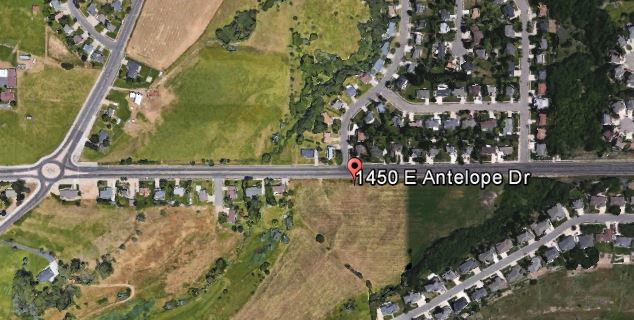
Supplied/Google Earth
Eastridge development on south side of Antelope Drive at 1450 East.
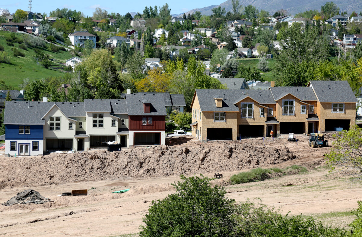
BENJAMIN ZACK/Standard-Examiner
The first townhomes in the Eastridge Park development along East Antelope Dr. are constructed on Wednesday, May 11, 2016. Some neighbors are worried about the traffic and potential for landslides as the hilly land in Layton is developed.
City officials and private and state geologists say they are confident of the project because its study has been deep and its engineering careful. That process included public comment, some of it from those fearing slide risks.
Layton City gave initial approval in 2015 to the phased development, expected to include 52 town homes, 76 single-family cottage homes and 140 single-family custom homes. It also will include a 16-acre city park, which will play a dual role as a landslide buffer protecting Kays Creek, and a connection to the Kays Creek Trail.
The site lies between the south and middle forks of Kays Creek and between Antelope Drive and Kays Creek Drive, east of Church Street.
The first step of construction was to grade the area and compact the soil.
“It’s good to do that rather than just build on a landslide,” said Rich Giraud, senior geologist with the Utah Geological Survey. “It’s best to stabilize it first. Layton is a good example of getting stabilization into the landslide before we build on it.”
Gregg Beukelman, another state geologist, said there’s no sure thing in landslide prevention in sensitive areas, despite exhaustive prevention work.
“It is so true that most landslides in Utah are reactivation of older landslides,” Beukelman said.
When a landslide occurs because the slope becomes unstable, for whatever reason, it will only stop moving when it comes to a “breaking point where resistance force equals driving force,” Beukelman said.
“That leaves a fragile configuration until something changes,” he said. “We see that a lot. There are some bad geologic units in northern Utah.”
The Eastridge project is near the Heather Drive and Sunset Drive slide sites, which in 2001 and 2006, respectively, saw severe damage to several homes, some of which were condemned.
The Utah Geological Survey report on the Heather Drive disaster is cautionary. The slide damaged six houses, three of them later demolished. The other three were moved. Damage estimates exceeded $1 million.
“Unfortunately, although the landslide was identified in a 1970s geotechnical study, a detailed site investigation was not completed to determine safe locations for the houses to be built,” the state report said.
During city council consideration of the Eastridge project, Mayor Bob Stevenson said the city had required Adams to jump through hoops for years to ensure the project area would be as stable as possible.
Scott Carter, strategic projects manager for Layton City, said the Eastridge work was preceded by seven years of reviewing soils and groundwater and “manipulating the landscaping to be safer.” That wasn’t done on Heather Drive or Sunset Drive, he said.
The Eastridge project also includes a network of land drains to route groundwater to Kays Creek, which will contribute to soil stability.
Story continues below image.
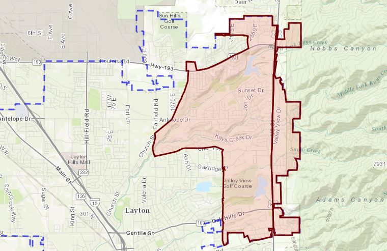
Supplied/Layton City
Area in red shows Layton’s sensitive lands zone
Aside from human impacts, and despite efforts to guard against landslides, blame prehistoric Lake Bonneville.
As the ancient lake receded from its high mark in the northern Utah foothills, it left sediments that became today’s slide-prone slopes.
Giraud explained that prehistoric Weber River delta sediments deposited in Lake Bonneville were later eroded into slopes as the lake dried up to its remnant, the Great Salt Lake.
“The delta sediments in these slopes are weak and prone to landsliding, as indicated by geologic evidence and historical records of landslide activity,” Giraud said.
It’s not just east Layton, either. Those sandy, sedimentary and clay soils make up much of the benches and slopes in South Ogden, Washington Terrace, Uintah, Riverdale and South Weber.
A color-coded map from the Utah Geological Survey shows sprinkled red areas, signifying high landslide danger, from North Salt Lake north to Brigham City. The high-danger areas are surrounded by larger belts of yellow-shaded areas — those in moderate danger.
Story continues below image.
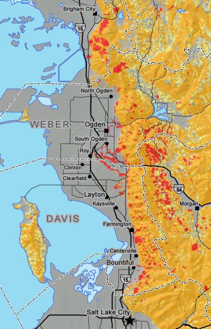
Supplied/Utah Geological Survey
Red areas on the map show high risk for landslides. Yellow signifies moderate risk, grey no risk.
Until the mid-2000s, the Utah Geological Survey conducted independent evaluations of city-contracted geotechnical evaluations at local governments’ request. Giraud conducted several of those himself in the 1990s and later, sometimes challenging conclusions reached by the private geologists. Such conflicting reports can cause cities to order additional studies or at least go slower on projects pitched by eager developers.
Now, state geologists usually only study slide-affected areas after a slide has activated, such as the 2014 slide that destroyed a home on Parkway Drive in North Salt Lake.
In Layton, the city is bullish about the Eastridge development.
“The mass grading according to geologists took care of the geological concerns and the potential landslides on the property,” Carter said in an interview Tuesday. “They have just basically evened it all out, the valleys are cut down, they evened the slopes and buttressed those areas that were potential slide areas.”
Kaylee Barson lives in a home on Antelope Drive just west of the project. She said she was aware of the region’s slide issues but is excited to see the development progress.
“I have no concerns,” she said. “It will be nice to have a bigger community here.”
You can reach reporter Mark Shenefelt at mshenefelt@standard.net or 801 625-4224. Follow him on Twitter at @mshenefelt and like him on Facebook at https://www.facebook.com/SEmarkshenefelt.
Environment
Changing the plan: O’Leary concedes to Utah Senate President Sen. Stuart Adams’ demands on data center
Governor declares drought emergency as Utah dips into reservoir ‘savings’