Record-breaking drought along Wasatch Front forces tough decisions about water supply
-
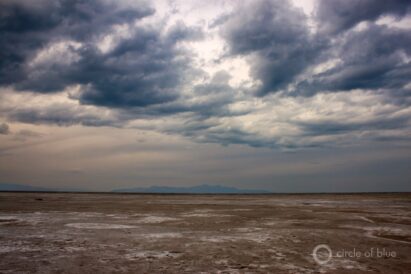
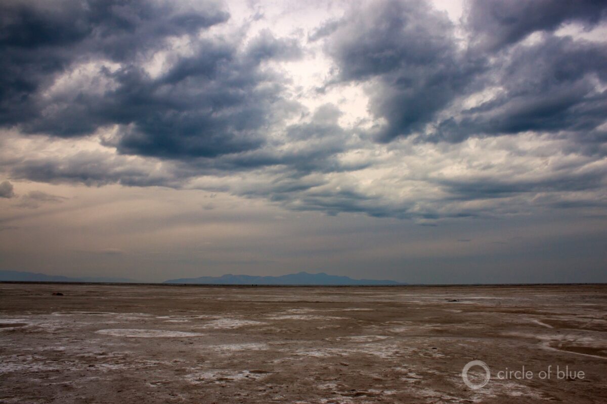
- The largest saline lake in the western hemisphere, the Great Salt Lake dropped to a record low in 2021 as a result of a hot drought that increased evaporation and decreased water flows.
-

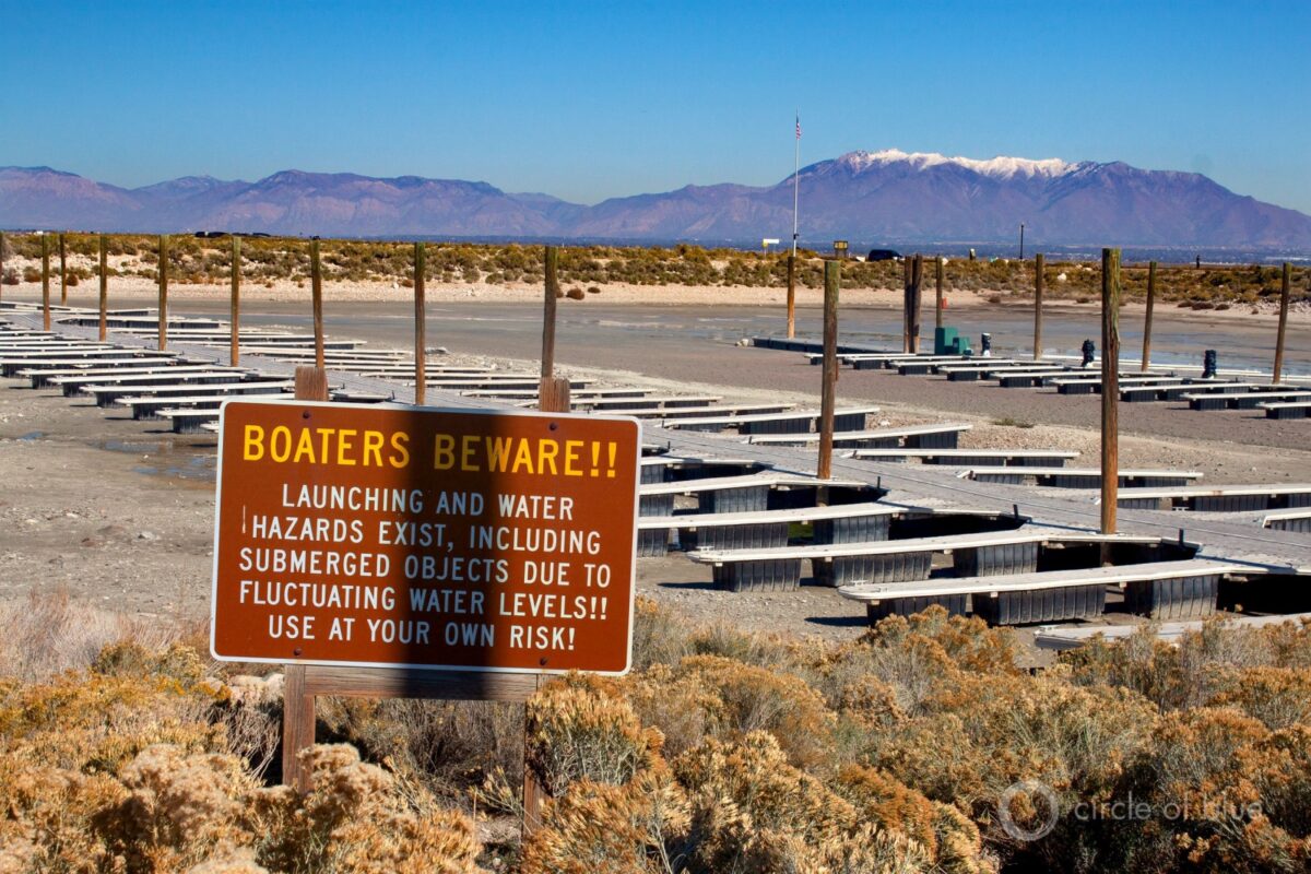
- At Antelope Island Marina, the Great Salt Lake has receded so much that the docks rest on sand.
-
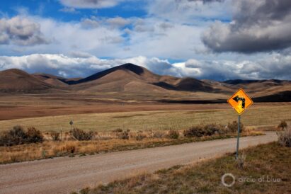
- A remote area where a handful of families farm dryland grain, Whites Valley is the prime reservoir site in the state of Utah’s plan to divert the Bear River. To reach Whites Valley, which is not located along the river, water would be piped 18 miles and pumped 1,000 feet in elevation.
-
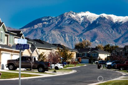
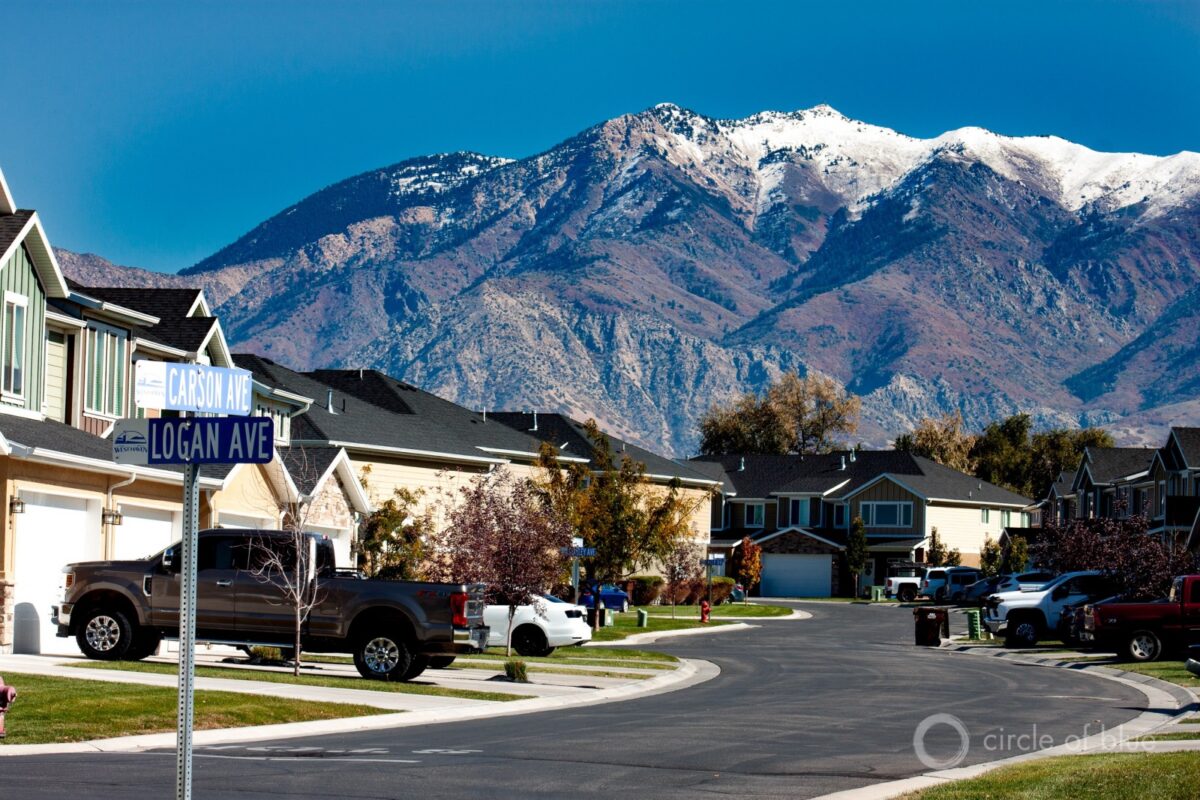
- Communities along Utah’s Wasatch Front are among the fastest growing in the country. The population of West Haven, shown here, grew by more than 60% in the last decade. This growth brings challenges. Utah residents use more water than residents in almost any other state. State officials and water district leaders say that landscaping decisions for new and existing developments need to be more attuned to water use.
Brett Walton, Circle of Blue
The largest saline lake in the western hemisphere, the Great Salt Lake dropped to a record low in 2021 as a result of a hot drought that increased evaporation and decreased water flows.
Editor’s note: This story was reported in partnership with the Institute for Nonprofit News. Nine INN newsrooms spent several months reporting on water justice issues in the rural Western U.S. The participants — California Health Report, Center for Collaborative Investigative Journalism/SJV Water, Circle of Blue, Colorado Public Radio, Columbia Insight, The Counter, High Country News and New Mexico In Depth — explored issues including contaminated water, drought, overuse of groundwater and land ownership.
BOX ELDER COUNTY – Sitting inside a shepherd’s trailer hitched to his white pickup truck, Robert Child recounts a lifetime spent running sheep in the pastures of northern Utah.
Wind gently rocks the compact trailer as Child, who is 75, describes the grazing rotations for his 2,000-head flock. Winters in Wendover, near the Nevada border. Summers in the high country above Logan. On a mid-October day he is here at the mouth of austere Whites Valley, where about five families harvest dryland grain, and where Child has leased grazing land for two decades.
“I don’t know any different,” Child says about his occupation, his blue eyes gleaming playfully. “It’s a sickness.”
It’s a sickness that might not last in this remote farm and ranch outpost. Whites Valley, a dimple in the sage-covered hills just south of the Idaho border, might not be an ag valley much longer. Its durability as an agricultural center, though, has almost nothing to do with the finances of its few residents. It has much more to do with the valley’s bowl-shaped topography, residential development miles away, and water.
Brett Walton, Circle of Blue
At Antelope Island Marina, the Great Salt Lake has receded so much that the docks rest on sand.
Whites Valley is the prime candidate for a 30-year-old dam and reservoir proposal to tap and store, in the words of the Utah Legislature, “one of the last major sources of developable water in the state.”
That source is the Bear River, the largest tributary of the shrinking Great Salt Lake. How much of the water is “developable” is a matter of debate. Called the Bear River Development, the $1.7 billion project, which would inundate the valley, has been a state objective since an act of the Legislature in 1991.
Whether the Bear River project makes sense, though, is a focus of intensifying discussion in a growing state contending with worsening water scarcity. State authorities want to develop new sources of water. But public interest advocates assert that spending billions of dollars to build pipelines to transport water from distant sources is foolish. Utah, they insist, can do much more to conserve its existing freshwater reserves.
In Utah’s southwest corner, the Central Iron County Water Conservancy District is championing the $260 million Pine Valley Water Supply project, currently under review by the Bureau of Land Management. If approved, the district would construct 66 miles of pipeline to access groundwater in neighboring Beaver County. Iron County grew by 24 percent in the last decade, adding 11,126 people. The county is currently overdrafting local groundwater supplies, resulting in land subsidence that has cracked paved roads and interrupted the flow of sewer pipes.
Farther south, the Washington County Water Conservancy District is also seeking more water. The district, serving a county whose population expanded by 30 percent in the last decade, has its eyes on a 140-mile pipeline from Lake Powell. That project is hung up in the permitting process and faces its own questions about its billion-plus dollar cost, justification, and water availability from a drying Colorado River basin.

Brett Walton, Circle of Blue
A remote area where a handful of families farm dryland grain, Whites Valley is the prime reservoir site in the state of Utah’s plan to divert the Bear River. To reach Whites Valley, which is not located along the river, water would be piped 18 miles and pumped 1,000 feet in elevation.
Each pipeline project raises questions that are fundamental to life in the arid western United States, and essential for Utahans to consider before the current homebuilding spree establishes land use and development patterns that will influence water demand for a generation: How do growing communities live with limited water? And will past behaviors be adapted to new climate and demographic realities?
Consideration of the Bear River Development follows the basic outlines of the clash. Not long ago, state authorities said water conservation efforts delayed the date the water would be needed to 2050. But the West’s megadrought, which produced severe dry conditions this year in Utah and across the Southwest, is a factor in again pushing the Bear River to the forefront. The Great Salt Lake, for example, dropped last summer to a record low, exposing more of the dry lake bed to windstorms that can worsen respiratory illnesses like asthma.
Another contributing factor is Utah’s attractiveness as a place to live. With its low unemployment rate (2.2 percent, second-lowest in the country) and a wealth of natural amenities (trademarked slogan: Greatest Snow on Earth), Utah is a magnet for outsiders. The state boasts the highest population growth in the nation, according to the U.S. Census. Most of that growth is concentrated along the Wasatch Front, the string of mushrooming communities at the western edge of the prominent Wasatch Range. If the Bear River is tapped in the coming decades, the water is earmarked for this region.
The combination of demographic changes, severe water scarcity, and the state’s warming climate raises fresh questions about the wisdom of tapping the Bear River. The Bear River Development would deliver two and a half times more water than the Lake Powell pipeline. That water would be distributed to the northern counties of Box Elder, Cache, Davis, Salt Lake, and Weber. Those counties grew by 13 to 18 percent since 2010; all except Cache are along the Wasatch Front. The clusters of “new home” signs that line arterial streets in exurb communities like Syracuse and West Haven indicate that growth in the region is far from slowing.
To manage this influx of people, conservation groups say that Utah, which boasts cheap water rates and some of the highest municipal water use per person in the country, could be doing more to curb water waste and eliminate unnecessarily lush lawns before it commits to multibillion-dollar dams and pipelines like the Bear River project.
Brett Walton, Circle of Blue
Communities along Utah’s Wasatch Front are among the fastest growing in the country. The population of West Haven, shown here, grew by more than 60% in the last decade. This growth brings challenges. Utah residents use more water than residents in almost any other state. State officials and water district leaders say that landscaping decisions for new and existing developments need to be more attuned to water use.
State officials say they have an opportunity to break out of the old Utah paradigm, in which water is used profligately. “How we grow today sets our water use patterns for decades to come,” Candice Hasenyager, director of the Utah Division of Water Resources, told Circle of Blue.
That path, though, is strewn with impediments and diversions. On one hand, state officials acknowledge the need to conserve. On the other, they favor building pipelines to satisfy the demands of Utah’s population centers. “I think it’s much cheaper to take water to the people than move people to the water,” Todd Adams, deputy director of the Utah Department of Natural Resources, said at the Utah Water Summit in October. “You disrupt a lot less lives that way.”
Tapping the Bear
These issues are always on the mind of Nathan Daugs, manager of Cache Water District. Located in Cache County, on the Idaho border, the district would be a beneficiary of Bear River Development.
“You have to find a way to continue with growth with the limited resource you have, and how do you stretch that resource further?” Daugs asked from his office at the Cache County Fairgrounds.
Bear River Development is why Daugs’ current job title even exists. Daugs and others in Cache County think that the prospect of diverting water from the Bear River inspired county residents five years ago to approve the water district’s formation, a proposal they had rejected twice before. Without a formal organization, Cache County and the river that flows through it might have been at the mercy of stronger, better endowed political forces outside the basin — behemoth water districts to the south like Jordan Valley and Weber Basin that serve some of the state’s biggest urban areas and are also granted Bear River water. “It was to essentially have a voice as that project moves forward with the state because if we didn’t have a formed district, we really didn’t have a seat at the table,” Daugs said. “A big thing is, how do we protect our allocation?”
The allocation Daugs speaks of was written into the Bear River project’s founding document. The Utah Legislature passed the Bear River Development Act in 1991 following a series of dry years, which were preceded by extremely wet years. The act put the Utah Division of Water Resources in charge of “developing” Bear River water — meaning moving it from the river to four water districts, two of which are located outside the basin.
The act says the state will provide 220,000 acre-feet a year from the Bear River. It grants 60,000 acre-feet each to Bear River Water Conservancy District and Cache Water District, the northernmost districts, both of which are inside the watershed boundaries and comparatively rural. The act also allocates 50,000 acre-feet each to two water districts outside the basin: Jordan Valley Water Conservancy District, which serves Salt Lake County, and Weber Basin Water Conservancy District, which serves the area around Ogden.
An acre-foot is the amount of water that will cover an acre of land to a depth of one foot, or 325,851 gallons.
Because of climate variations the Bear River’s annual flow has steep peaks and valleys. If 220,000 acre-feet is to be made available each year, the state reckons that substantially more storage will be needed. An assessment completed for the state in 2019 estimated that reservoir capacity ought to be at least 400,000 acre-feet.
Whites Valley is the prime reservoir site not because it is the most convenient, but because it can hold the most water. The Bear River is not even visible from Whites Valley — water stored there would be pumped from 18 miles away, requiring a vertical lift of 1,000 feet. There are other, smaller reservoir sites under consideration that could be paired with the Whites Valley site.
All this infrastructure means relatively expensive water. Bear River and Cache would pay $21.9 million a year for 50 years and Jordan Valley and Weber $18.2 million a year. That’s based on a $1.7 billion project and 4 percent interest. But for Jordan Valley and Weber Basin, it does not include a $295 million water treatment plant, a $173 million pipeline to bring treated water to the districts, and a $75 million reservoir to hold the treated water.
Even though the water districts do not immediately desire the water, the state is proceeding with surveys and land acquisition in order to secure a right of way before new homes crowd out preferable routes. Since 2018, the state has spent $3 million from sales tax revenue to secure a pipeline corridor.
Cache County, however, prefers a different option from the state’s design. Daugs said he would rather build incrementally, adding storage capacity to coincide with increases in demand. This would entail a series of small reservoirs, maybe 5,000 acre-feet to 10,000 acre-feet capacity. One concern with that idea is that a proposed dam site on Temple Fork is prime habitat for Bonneville cutthroat trout and beavers, which have constructed elaborate dams of their own in the area. Another problem: the small-reservoir option was not considered in a 2019 state feasibility study. Daugs said he wants to work with lawmakers to reconsider how Bear River Development might proceed.
Regardless of the options, the project is too expensive for tiny Cache Water District.
“Either way, it’s more than we can afford right now,” Daugs said. Cache County residents pay the water district $275,000 annually through property taxes. “If I tell them, we have to go to $25 million. What does that do to their tax bill? So certainly right now, that’s not an option. But that’s another advantage of doing those smaller reservoirs. We could bring them online as needed.”
Carl Mackley had similar thoughts about the odd quartet of water districts. Mackley is the general manager of Bear River Water Conservancy District, which supplies water to about 18,000 Box Elder County residents.
“When you anticipate needing it at different times, it’s really hard to tie everybody together under one project that may not necessarily serve your needs immediately, or even be in your own interest,” Mackley told Circle of Blue. Like Daugs, Mackley would prefer smaller projects.
Both Mackley and Daugs said that in the short term, they might consider leasing the water to other users, maybe to Jordan Valley or even to the Great Salt Lake, to buttress it against what is turning out to be a long-term decline.
“I mean, as for drinking water, you know, we don’t need it for decades longer than the Wasatch Front needs it under current projections,” Daugs said. Though he brings up one caveat: all of Cache County’s drinking water comes from springs and wells. Those are great sources today, he said. But what if that changes? Last summer Hyde Park, a smaller community, saw its spring dwindle and officials had to notify residents to stop watering, he said. “So that’s where I have a little argument with the state in that our reliable source may not be as reliable as they’re claiming it is.”
Using Less
Reliability is the holy grail of water planners. That is reasonable given that they deliver an essential product. The dams and reservoirs in their toolbox are a means to that end, storing water in wet periods for later release.
Water managers in Utah got a glimpse this summer of extreme conditions that test reliability. Soil moisture was at a record low. The Great Salt Lake dropped to a record low. Reservoirs were at critical levels. Eighty-five percent of the state was in “extreme” or “exceptional” drought conditions, the worst ratings on the U.S. Drought Monitor. When supply was cut so drastically, managers responded by ratcheting down demand.
Mackley said that Bear River Water Conservancy District wanted to get “pretty aggressive” about conservation. “Basically we wanted everyone to have a brown lawn,” he said. The district raised its water rates for heavy users and allowed wholesale customers to take less than their contracted amount without penalty. The district read meters weekly, and it posted the water use data on its website to reinforce behaviors. The district notified customers about all of this and held a public meeting to present its plan to cut outdoor water use by 50 percent and indoor use by 20 percent.
Green, manicured lawns are a defining feature of Wasatch Front communities. Bart Forsyth, the general manager and CEO of Jordan Valley Water Conservancy District, said that the average summer peak demand — how much water the district delivers when lawns and gardens are thirstiest — is about six times greater than winter base demand, which is primarily indoor uses like drinking, cooking, bathing, washing. That puts enormous strain on water supply systems.
“Basically, our water infrastructure — all the millions of dollars that we’re putting into water supply, water delivery infrastructure — is driven by landscape watering. And naturally, if we can reduce landscape watering significantly moving forward, then there will be tremendous cost savings associated with infrastructure,” Forsyth told Circle of Blue.
Jordan Valley is promoting changes in municipal landscaping codes that would reduce the size of new lawns and shrink summer peak demand. Forsyth said peak demand could perhaps be cut in half; early results from the landscaping initiative suggest it’s possible. In Seattle, for comparison, where golden lawns in summer are common, even during the height of the city’s June heatwave this year, when the temperature cracked 100 degrees for three consecutive days, peak water demand topped out at about two times the winter average.
It’s not an exact comparison, of course. The Wasatch Front is warmer in general than Seattle, and soils in Seattle were boosted before the heatwave by a mid-June rain. Still, environmental advocates look at these figures and think that Utah has a long way to go before it maxes out its water conservation potential and before it needs to consider multibillion-dollar projects like diverting the Bear River.
Zach Frankel, executive director of the Utah Rivers Council, an environmental group, opposes Bear River Development and is particularly critical of the state’s water conservation targets. “The rest of the country is 20 years ahead of us” on conservation, Frankel told Circle of Blue.
The Utah Department of Natural Resources, in a 2019 report, set new state and regional water conservation goals for municipal and industrial use. The targets extend to 2030, 2045, and 2065 and are all set against a 2015 baseline of 240 gallons per person per day.
Statewide the goal is to reduce demand 16 percent by 2030. After that the pace of the conservation goals slows. The 2040 goal is a 22 percent reduction. The 2065 goal is a 26 percent reduction.
Year after year, Frankel has seen water conservation bills weakened in the Utah Legislature or die in committee. The best leadership on water conservation in the state, he says, comes from cities.
What could Utah do instead of spending billions of dollars on Bear River Development? Frankel has a list, from collecting better water use data to aligning water rates with the cost of service and relying less on property taxes to fund water districts. Irrigation water could be directed to cities as farmland is converted to less thirsty subdivisions.
A top recommendation is to transform Utah’s unusual institution of “secondary water.” Utah’s urban growth is occurring primarily on lands that were converted from farm fields. Frankel’s own house sits on land that used to be a tulip farm. The irrigation infrastructure that nourished the farms in many cases has been repurposed to provide untreated water for suburban lawns. A portion of these secondary systems are piped. But others are open canals or ditches. In summer, the water in some places flows through the street gutters, like a river along the road. Homeowners, who pay a pittance for access to this water, drop a pump into the gutter and flood their yards. The state estimates that 30 percent of municipal and industrial water is used in secondary systems.
Weber Basin Water Conservancy District, which is allocated Bear River water, is in the midst of an initiative to meter all its piped secondary connections. The district is already seeing results. Meters generate data, and data can change behaviors. Just providing residents with information about how much water they are using resulted in a 20 to 30 percent water savings. The Department of Natural Resources is now seeking $50 million in the state’s American Rescue Plan Act allocation to install secondary meters. If all the state’s 260,000 secondary customers had meters and achieved reductions similar to Weber Basin, the department estimates an annual savings of 50,000 acre-feet. That’s before any price increases are factored in, which would cut outdoor use even more.
With these sorts of outcomes, Frankel is not the only one who thinks Utah could make more effort to promote conservation.
“The 2030 goal shows reasonable conservation progress,” said Peter Mayer, a water demand expert who runs the consulting company WaterDM.
Though the short-term goal is reasonable, in the longer run the state’s conservation plans do not show enough ambition, Mayer told Circle of Blue. “Beyond 2030 minimal additional progress is expected according to the report. The conservation goal for 2065 is weak and suggests a lack of seriousness to reduce municipal demand over the long haul, to achieve water use levels proven possible in other states across the western U.S.”
Wings of Thunder
Near the mouth of the Bear River, before it empties into the Great Salt Lake, visitors will find an oasis. On the broad plain west of I-15 the river slows, its course a squiggle. Here water spills between man-made rectangular impoundments, the surfaces so still they mirror the sky. Only mallards and duck hunters break the illusion.
This is Bear River Migratory Bird Refuge, a 77,102-acre desert wetland established as a bird sanctuary by Congress in 1928. About 210 bird species have been spotted at the refuge, which is a critical breeding, nesting, or foraging site for the Great American Flyway, including species like the long-billed curlew, American white pelican, and white-faced ibis.
Overseeing this expanse is Erin Holmes, manager of the refuge for two and a half years. Holmes arrived at her post after a stint at Tualatin River National Wildlife Refuge, outside of Portland, Oregon. Moving from the water-sensitive Pacific Northwest to the arid Wasatch Front delivered an initial culture shock.
“The first thing I noticed that people think differently was the perfect green lawns,” she said. The move happened early in the summer. “It’s 104 degrees,” she recalled thinking. “Why are you watering the lawns?”
Holmes, wearing hawk earrings as we spoke, is fiercely proud of the national wildlife refuge system and the species it shelters. One morning at the Bear River refuge she saw what appeared to be a rapidly shifting cloud on the horizon. After a moment she realized it was a flock of swans, murmurating. So many bird species visit Bear River — shorebirds in July and August, avocets and grebes in October, tundra swans and trumpeter swans in mid-November — that the wetlands resound with their movements. The video playing on loop in the visitor center is titled Wings of Thunder.
Having spent her career at these places, Holmes knows what makes the system tick.
“Every refuge is about water,” she said.
If the Bear River Development proceeds, it will place more stress on bird habitat in the region. The river provides more than half of the surface inflow to the Great Salt Lake. The state feasibility study estimated that Great Salt Lake levels would decline by 8 to 14 inches because of the project.
The pressure, though extreme this year, has been slowly building. In 2019, the Utah Legislature ordered a report on actions that could help preserve the Great Salt Lake and its wetlands. The report was filed in December 2020. It recommended many of the conservation projects that water districts and cities are now considering: expanded metering of residential irrigation water, better data collection to understand how water is being used, bringing land-use planners and water providers together, reducing lawn sizes. Completing these, the report said, could “delay or forestall major public water development projects in the Bear River and elsewhere.” Delaying or forestalling those projects would “benefit lake levels and save taxpayer money.”
Even this year, before any Bear River diversion, water at the refuge was scarce. Because of the drought, Holmes and her staff had to be discerning with limited supplies. Not all the impoundments could be filled. Those that weren’t were left dry.
“We weren’t able to provide as much habitat,” Holmes explained, redwing blackbirds trilling in the marsh behind her. “Birds can fly though, and they move to another place.” But with the drying of the Great Salt Lake, options are limited. “My concern is that there are not many places to go. No water equals no habitat.”
In Whites Valley, Robert Child is attuned to these discussions, but at a distance. He’s seen technicians at the valley mouth, testing the stability of the slopes and the durability of the geology to the forces that a dam would exert.
If the reservoir were to be built in the valley, relatively few households would be disturbed. But it would end a way of life. Fields would be submerged. Herding would probably come to a halt. Child said you couldn’t graze sheep around the perimeter of the reservoir because they’d bury themselves in the mud. All in all, he questions the wisdom of the project.
“Why come up and ruin this area for people in Salt Lake?” Child asks. “Ruin your own ground.”
Soothing sentiments like these will be part of the political dance around the Bear River. Rural areas across the American West, from Owens Valley in California to Great Basin communities in Nevada, have revolted, sometimes successfully, against outsiders attempting to move water to distant cities. Population growth and a warming climate will continue to stoke those debates along the Wasatch Front as the region figures out how to live with more people.